Radar Stations and the ROTOR Project
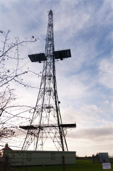
The advent and increased use of radar during the Second World War had become increasingly widespread across the UK but the early radar sets had several drawbacks: It was able to detect aircraft approaching at medium altitude but was unable to do much more than that. As the threat from WW2 passed many Chain Home Radar stations were closed down and mothballed into care and maintenance but by the 1950’s tensions were rising with a new enemy, the USSR, and once again Britain found herself needing to protect and defend her sky yet found that the infrastructure was not in place to do so. Improved radar equipment was being developed as fast as possible and was hastily put into place to provide a modicum of early warning of incoming soviet bombers.
To this end existing Radar stations where refitted and brought out of ‘care and maintenance’ in their original CHAIN Home configuration, these were intended to supplement the new radars that were being installed in the various new ROTOR radar Sites around the country. The new sites were to be 25 Ground Controlled Intercept Stations (GCI), 8 Centimetric Early Warning Stations (CEW), 26 CHAIN HOME Stations, and 6CHAIN Home Extra Low (CHEL) Stations, all of which were to be controlled by 6 Sector Operations Centres (SOC’s) at Barnton Quarry, Bawburgh, Box, Kelvedon Hatch, Longley Lane, and Shipton. It is worth noting that Bawdsey was a combined CH/GCI site and Ventnor was a combined CEW/CH site.


The stations used standardised radar of the time of the models type 7 GCI sets and type 11 CHL/GCI sets and the type 13 CM-H and type 14 CHEL/GCI sets.


The newly designed and built, protected underground ROTOR Bunkers were easily recognisable from their characteristic guardroom bungalow and surface support buildings (vent shafts, radar bases etc) they followed a more or less standard design blueprint. The reason the ROTOR bunkers were built underground was not to provide them with an element of secrecy by hiding but to provide the operators and delicate electronic equipment with a certain degree of protection from bomb attacks. The main stations to be built underground were the ones in the areas judged to be in areas most at risk of bombing. They were originally intended to work in groups of three with all three radar functions covered by the three sites (CEW, CHEL and GCI). The GCI would be at the centre with the CEW and CHEL sites located remotely and reporting back to the GCI site.
They were built underground in the following formats, their layouts can be found to the right:
- R1 – Standard single level underground Centrimetric Early Warning (CEW) Station
- R2 – Standard single level underground Chain Home Extra Low (CHEL) Station
- R3 – Standard double level underground Ground Control Intercept (GCI) Station
- R4 – Standard triple level underground Sector Operations Centre (SOC).


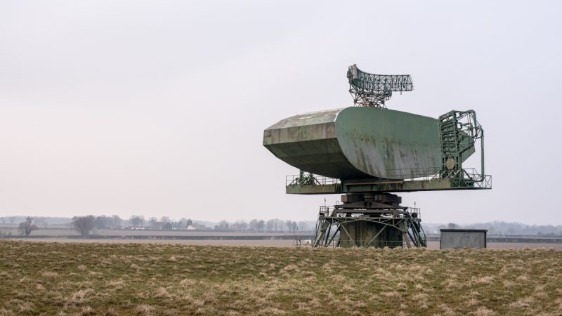
In 1953 the newly designed Type 80 radar and the AN-FPS6 Height Finder Radar arrived arrived and the sites could suddenly perform both CEW and GCI functions at the same site. This greatly increased the efficiency and range of the radar and as a result less sites where needed to maintain the air coverage. Many of the Radar stations were therefore closed down, transferred to other government departments, or mothballed back to ‘care and maintenance’ including the four R4 SOC’s, and many sites were later sold into the public sector. The remaining ROTOR sites where remodelled as Master Radar Sites this stage was known as the ‘1958 Plan’ (which is expanded on in greater detail below). Many of the ROTOR bunkers that were built were only commissioned and operational for a few years before they were shut down and many were never more than in an operational standby mode, many more found new uses with other government departments as the Cold War progressed but many did not and were merely left empty, buried and forgotten.


Later on in the ROTOR project less vulnerable areas such as inland sites where provided with above ground semi-hardened or unprotected (dependant on perceived risk) radar stations in the following formats:
R5 – surface GCI Station – later abandoned as unworkable and none were constructed.
R6 – Semi sunken GCI Station Similar to R3 but most of the ‘bunker’ is above ground
R7 – Underground ‘well’ used for type 7 radar (this was sited as a small auxiliary bunker around 2km from the main ROTOR bunker the type 7 radar served)
R8 – ‘Seco’ Surface GCI Station (non-hardened)
R9 – Converted WW2 ‘Happidrome‘ GCI Site (later abandoned)
R10 – above ground CEW station similar in design to the R1 sites
R11 – above ground CHEL site similar in design to R2 Sites
There was also some special variants that were site specific, such as:
R12 – equipment and plant room for type 85 radar
R15 – Data handling for high speed aerial
R17 – equipment and plant room for type 84 radar
R30 – built at RAF Neatishead only (converted WW2 surface ops room)
R31 – technical control building (e.g. RAF Bishops Court)

The ROTOR Project was divided into 3 distinct stages:
Stage 1
This was the reactivation of 28 WW2 CHAIN Home Radar stations. 13 were completely full time operational and 15 were in a suspended ‘state of readiness’ and the immediate construction of 14 new CEW and CHEL stations underground. This was scheduled for total completion by summer of 1954. The actual schedule was as follows:
1) Reactivation of WW2 CHAIN Home sites by March 1952
2) Completion of new CEW and CHEL sites by end of 1952
3) Completion of all underground GCI stations by mid 1953
4) Completion of remaining surface GCI stations and underground SOC’s by winter of 1953/4 with decentralised filtering available by summer 1954.
At the time this was the largest defence capital project ever undertaken with a total budget of £51.5 million pounds (1953 prices) and was known as ‘Operation ROTOR 1’

Stage 2
This was the construction of 11 underground GCI stations as well as the upgrading of other sites with a new radar called a Type 80, which was capable of detecting to a longer range and thus giving greater early warning times. This was known as ‘Operation ROTOR 2’ This element of the ROTOR project was approved in 1952 and construction began in 1954 (a few stations were upgraded early during 1952) and was scheduled for completion in 1958.

Stage 3
This was the construction of 14 semi-submerged or above ground GCI Stations as part of the move to address inadequacies discovered during the initial ROTOR 1 project. These sites where to provide radar cover to the North and West of the British Isles, and Low and Surface level cover over the sea approaches to Glasgow, Liverpool, and Bristol which were vulnerable, unprotected areas. This was known as ‘Operation ROTOR 3’ as was scheduled for completion in 1957.
The End of ROTOR
When ROTOR 1 was completed thirty nine new stations (thirty four underground) were handed over to Fighter Command in April 1956. By this time some stations had already been closed, or put into ‘Care and Maintenance mode’ and operation ROTOR 2+3 where in full swing, but the type 80 radar upon which so much of the ROTOR project depended was already in jeopardy and a review of its efficacy was already in hand even before the project was finished. This review recommended nine sectors each of which would have a comprehensive radar station that would perform a CEW/GCI function using type 80 radars each supported by a satellite control station and dedicated CEW station. This was split into 3 phases:
1) Conversion of eight existing GCI stations into comprehensive radar stations and the construction of one new radar site.
2) Conversion of a further nineteen existing ROTOR stations into satellite control stations or type 80 equipped CEW stations
3. The introduction of a fully automated and computerised data handling system.
This review was known as the ‘1958 plan’ and was the forerunner of modern radar and air traffic control systems with updated and even more efficient radar and data handling systems. Ultimately the system was replaced with the LINESMAN/MEDIATOR using the type 84 and 85 radars, which then ultimately evolved into modern, integrated air defence.

References:
Cold War Secret Nuclear Bunkers, Nick McCamley, ISBN 9781844155088, from www.pen-and-sword.co.uk
All archive images found within this page have been reproduced courtesy of Subterranea Britannica www.Subbrit.org.uk
- Google Maps ROTOR Bunker Locations
- RAF Barnton Quarry R4 Rotor Bunker SOC and RSG, Edinburgh
- RAF Bawdsey ‘PKD’ R3 GCI ROTOR Radar Station
- RAF Bempton ‘RMF’ CEW R1 ROTOR Radar Station, Yorkshire
- RAF Bishops Court/Killard Point R8 GCI Control and Reporting Post/ULSTER Radar
- RAF Chenies ‘HAM’ GCI R8 ROTOR Radar Station, Buckinghamshire
- RAF Holmpton “VQJ’ GCI R3 ROTOR Radar Station, Yorkshire
- RAF Hope Cove ‘HOP’ GCI R6 ROTOR Radar Station & RGHQ 7.2, Devon
- RAF Kelvedon Hatch ‘XSL’ R4 ROTOR Sector Operations Centre and RGHQ 5.1, Essex
- RAF Murlough Bay ‘URB’ CHEL R11 ROTOR Radar Station, County Antrim
- RAF Neatishead R3 and R12 GCI ROTOR Sector Operations Centre, Norfolk
- RAF Portland ‘NIB’ CEW R1 ROTOR Radar Station, Dorset
- RAF Treleaver ‘TEL’ R6 GCI ROTOR Radar Station, Cornwall
- RAF Trerew ‘RTW’ CH ROTOR (WW2 reactivated) Radar Station, Cornwall
- RAF Wartling ‘ZUN’ R3 GCI/CEW ROTOR RADAR Station, East Sussex
- ROTOR Bunker List
- ROTOR Interior Plans
- Royal Signals and Radar Establishment, Malvern


Comments are closed.