

Google is filled with many wonders, such as the hot-linked plan below from the following link https://wolvertonpast.blogspot.co.uk/2011/05/wolverton-in-its-prime-1-works.html:
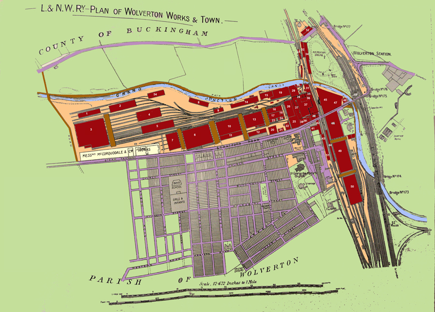
The above plan was taken from a map dated circa 1905. The new Radcliffe Trust development of Peel Road, Jersey Road and Anson Road is underway, but not yet complete. The Carriage Works however, has reached the full western extent of its development. There were changes to come, but in terms of territory, this was the limit. The workshops and principal buildings have been numbered and a table and sectional views follow below.
Wolverton Works c. 1905
Reference to Workshops and Sheds
1 Timber Gantry
2 Timber House
3 New Paint Shop
4 Timber Stores
5 Lifting Shop
6 Carriage Repairs
7 Wheel & Axle Shop
8 Timber Drying Shed
9 Power Station
10 Horse Box Shop
11 Parcel Cart and Omnibus
12 Finishing Shop
13 Body Shop
14 Saw Mill
15 Carpenter’s Shop
16 Underframe Shop
17 Underframe Shop
18 Electrical Shop
19 Smith’s Shop
20 Finishing Shop
21 Time Office
22 Dining Hall
23 Polishing Room
24 Polishing Room
25 Bogie Shop
26 General Stores
27 Fitting Shop
28 Wheel Turning Shop
29 Forge
30 Brass Foundry
31 Iron Foundry
32 Tin Shop
33 Engine Shed
34 Lifting Shop
35 Gas Fitters’ Shop
36 Brass Finishing Shop
37 Brake Shop
38 Tool Room
39 Testing Room
40 General office
41 Laundry
42 Accumulator Shop
43 Accumulator Shop
44 Washing Shed
45 Paint Shop
46 Paint Shop
47 Trimming Shop
48 Sewing Room
49 Paint Shop
50 Carriage Finishing
51 Electrical Shop
52 Gas Works
53 Wolverton Station
Below is another plan showing the extent of the Works
